Northland Reliability Project

Virtual open house

Thank you for joining us online today. This project is part of a regional plan for energy reliability. Minnesota Power and Great River Energy are working together to build the Northland Reliability Project.

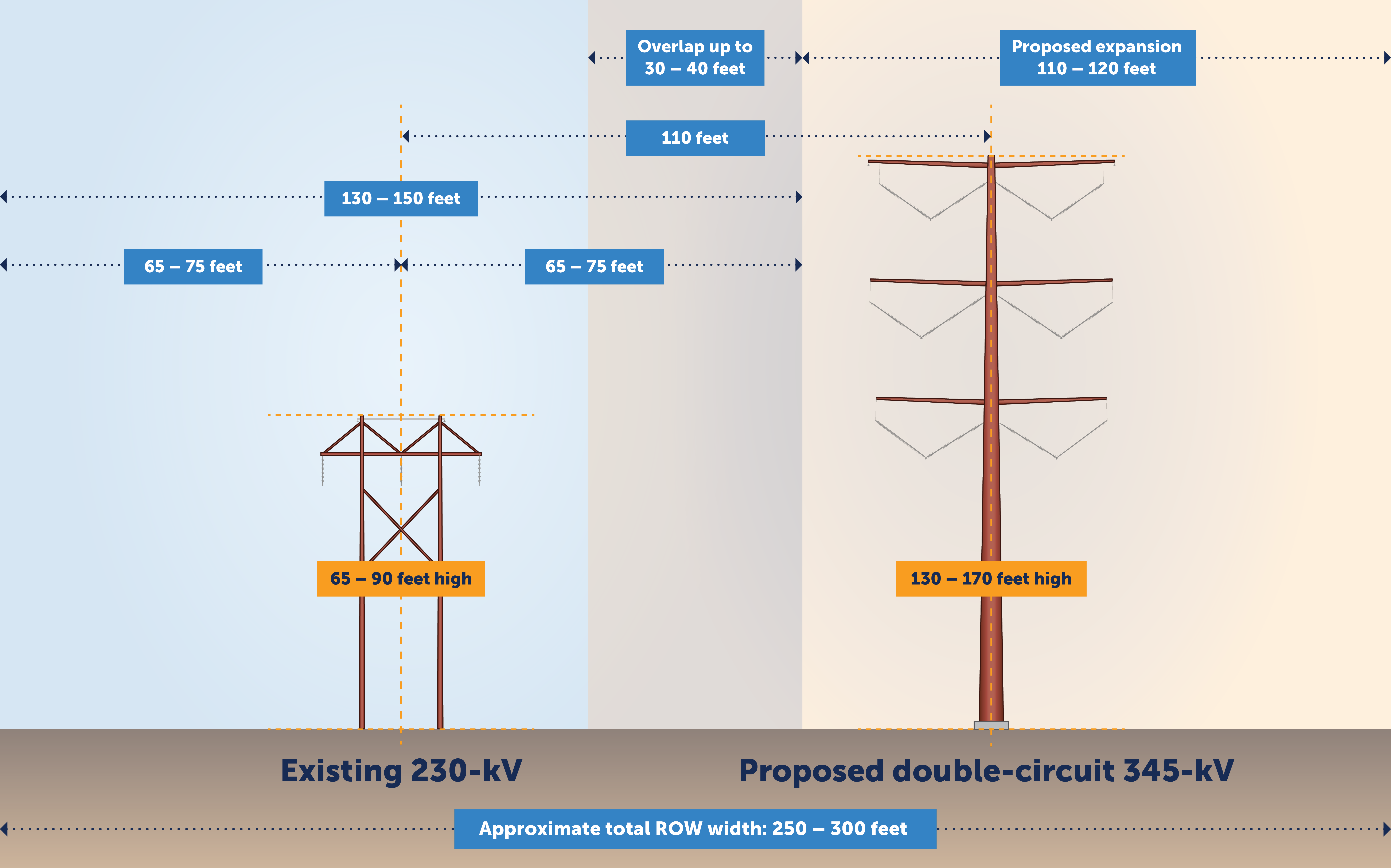
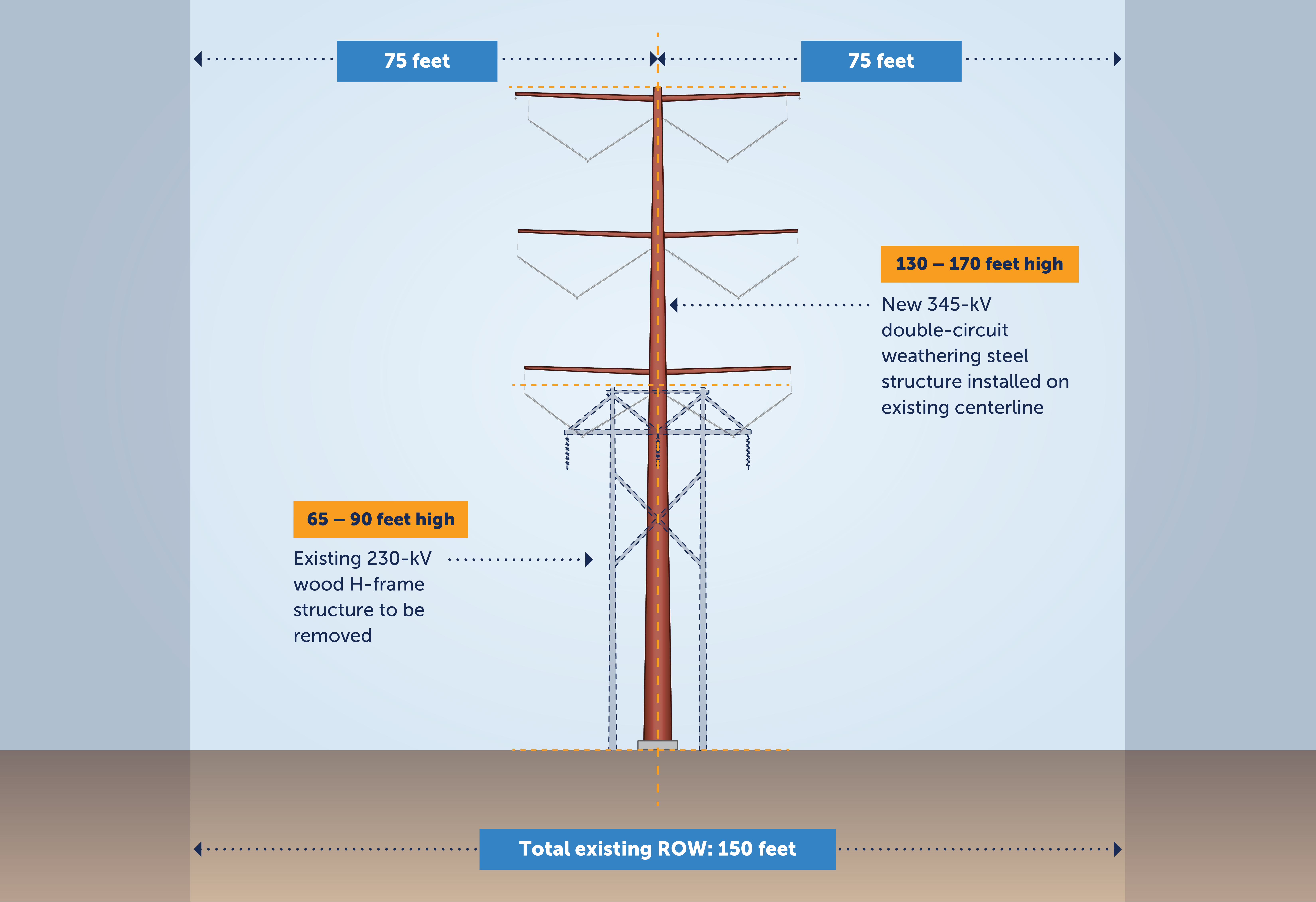
The project includes new and replaced transmission lines, upgrades to existing substations and a new substation. When in service, the transmission grid will be more reliable, resilient and flexible to support the delivery of cleaner energy to our customers and members.

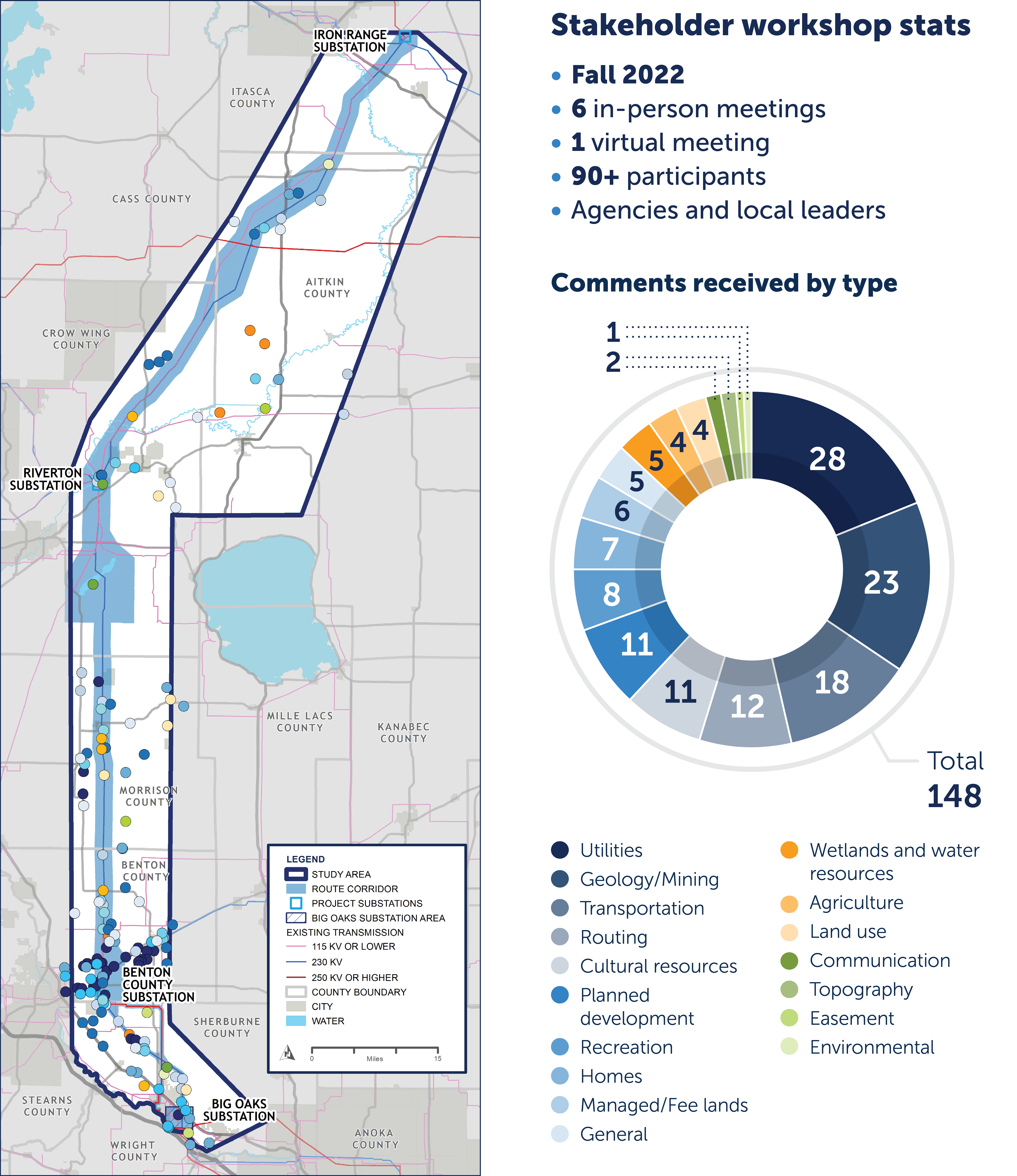
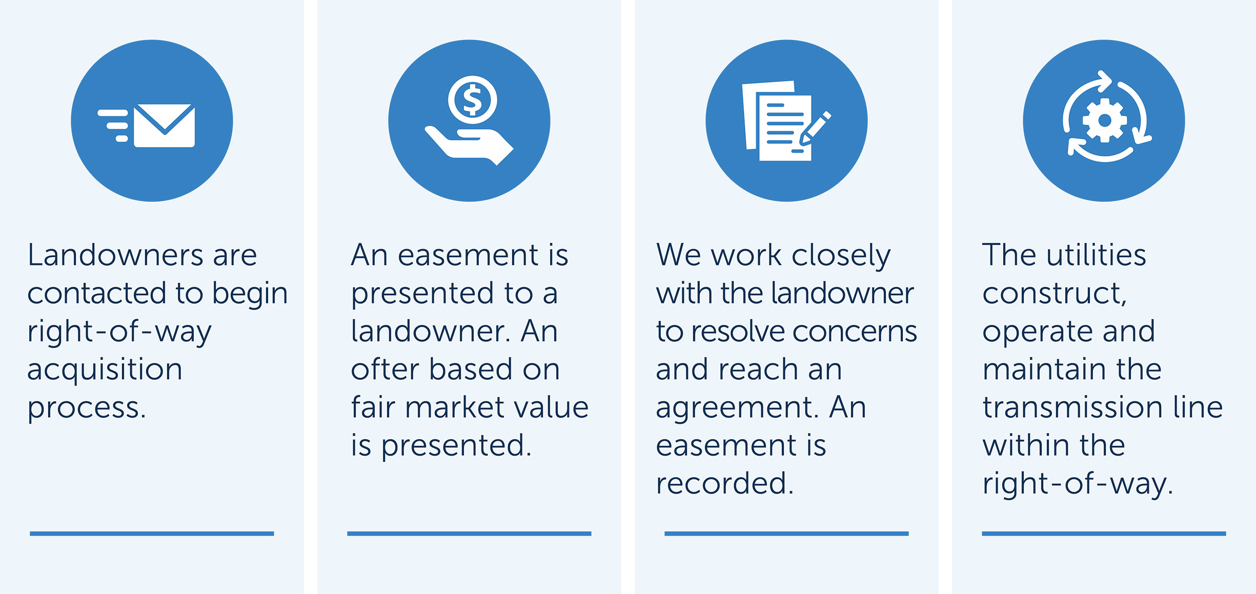
We need your input to help us identify a proposed route for this new line. On the following slides you’ll learn more about the project, review route corridor maps, and provide input about routing opportunities and constraints.

Launch the open house

Who we are

Minnesota Power

Minnesota Power is a utility company that provides, affordable, reliable energy to 145,000 residential customers and business customers in NE MN and 14 municipalities and some of the nation’s largest industrial customers in Minnesota.

Great River Energy

Great River Energy is a wholesale electric power cooperative which provides electricity to approximately 1.7 million people through its 27 member-owner cooperatives and customers. Through our member-owners, we serve two-thirds of Minnesota geographically and parts of Wisconsin.

About the project

To maintain a continuous supply of safe and reliable electricity, Minnesota Power and Great River Energy are investing in our transmission infrastructure to enhance the stability of the regional electric system and support a reliable, resilient and flexible grid as energy resources continue to evolve.

Minnesota Power and Great River Energy plan to build an approximately 150-mile, double-circuit 345-kilovolt (kV) transmission line from northern Minnesota near Grand Rapids to central Minnesota near Becker to support grid reliability in the Upper Midwest.

MISO, the regional grid operator, approved this project as part of a portfolio of Long Range Transmission Projects in July 2022. Learn more at misoenergy.org.


Click on image to enlarge.


Click on image to enlarge.

Project timeline

We'll undertake a robust stakeholder process as we prepare to apply for a Certificate of Need and Route Permit from the Minnesota Public Utilities Commission. Please note the schedule is subject to change.

  • 2022

    Project planning and initial stakeholder engagement

  • 2023

    Routing, public engagement and permitting

  • 2024 - 2026

    Permitting, engineering, environmental surveys, real estate and public engagement

  • 2027 - 2030

    Construction

  • 2030

    Anticipated in-service

Two main project segments

The project consists of two major segments and additional improvements as shown in the route corridor map:

Segment one: New double circuit 345-kV line

Iron Range Substation to Riverton Substation to Benton County Substation

  • Approximately 130 miles
  • Opportunities to route near existing transmission lines
  • Connect into new Riverton Substation

Segment two: Replacement with a double-circuit 345-kV line

Benton County Substation to Big Oaks Substation

  • Approximately 20 miles
  • Verifying existing right-of-way is suitable for a 345-kV line
  • NOTE: The Big Oaks Substation is being built as part of a separate project

Additional project improvements

  • Expand the existing Iron Range and Benton County substations
  • Install a new substation and reconfigure existing transmission lines in the Riverton area
  • Rebuild approximately 20 miles of existing line from the Benton County Substation to the Sherco Substation in Sherburne County

Click on image to enlarge.

Why is the project needed?

The Northland Reliability Project will support continued reliable electric service in northern and central Minnesota, as well as the greater Upper Midwest region. It will:

  • Provide system support

    Provide support to the energy grid as more renewable energy is brought online and coal operations cease at existing power plants.

  • Increase capacity

    Safely and reliably deliver more clean energy from where it’s produced to where it’s consumed by utility customers and power cooperative members.

  • Strengthen resiliency

    Improve ability to withstand more frequent extreme weather events.

  • Enhance flexibility

    Meet future energy needs by enabling transfer of many types of power generation from many locations to meet the long-term needs of our customers and members.

Our routing process

Routing a transmission line is no small task. The state of Minnesota has statutes and rules that guide the route selection process and help minimize a project’s impact to human settlement and the environment. Input from you, local leaders and agencies as well as our own expertise is critical as we develop and finalize a route.

We’re currently in the phase of our routing process where we’ve defined the route corridor. Please note that at each point during this process, and even after we submit our Certificate of Need and Route Permit to the Minnesota Public Utilities Commission, there will be opportunities for public engagement.


Click on image to enlarge.

Routing phases

Our team started by using data from publicly available data sources and federal, state and local agencies to define a study area. We considered existing utility corridors, existing land use, resource areas and other data to help identify opportunities to eventually identify a proposed route.


Click on image to enlarge.

Our team used data collected from your local leaders and federal, state and local agencies and the categories of routing criteria—opportunities and constraints—to define a route corridor. The route corridor is a narrowed area being considered for the power line. We developed the route corridor based on where the new power line will need to connect into substations, input gathered during our fall 2022 stakeholder workshops and the opportunity to route near existing utility corridors and land already being used for power lines. The route corridor is narrower than the original study area, and wider than the 150-foot right of way that will be needed for the construction, operation and maintenance of the line.

A map of the route corridor is shown later in this online meeting.

We will evaluate public input from Step 2 and develop route alternatives. Join our mailing list to stay updated on project milestones.

We will develop a proposed route that we will use to submit a Certificate of Need and Route Permit with the Minnesota Public Utilities. Join our mailing list to stay updated on project milestones.

Input opportunity: opportunities and constraints

The comment period has closed

Input opportunity: comment map

The comment period has closed

Right-of-way

We’ll need additional right-of-way to install, operate and maintain this new transmission line and additional project improvements. We’re proposing 130- to 170-foot high single-pole structures with arms on both sides of each structure to carry the lines. We anticipate having about five to six structures for each mile of our line. This typical design for the transmission line influences our right-of-way needs for the project.

A right-of-way is a strip of land used for a specific purpose such as the construction, operation and maintenance of a road or transmission line. Right-of-way is typically secured as an easement on a property. The landowner retains ownership of the land subject to the easement.

A document allowing Minnesota Power and Great River Energy the right to construct, operate and maintain a transmission line and other associated infrastructure on your property.

Project representatives will hold individual meetings with affected landowners to discuss our right-of-way needs.

Landowners are contacted and an easement is presented based on fair-market value. We work to reach an agreement and the utilities maintain the transmission.

Beyond the right-of-way needed for the transmission line, additional needs may include:

  • Construction staging areas
  • Temporary access roads
  • Substation expansions

Right-of-way needs: Segment one

Segment one consists of approximately 130 miles of new double-circuit 345-kV transmission line from the Iron Range Substation near Grand Rapids to the Benton County Substation near St. Cloud. The typical right-of-way needed for a new proposed transmission line is 150 feet. When a new line is located near existing lines, there may be an opportunity to share up to 30 - 40 feet of right-of-way with existing transmission lines.

Right-of-way needs: Segment two

Segment two consists of replacing approximately 20 miles of existing transmission line with a new double-circuit 345-kV transmission line from the Benton County Substation near St. Cloud to the new Big Oaks Substation that will built as part of a separate project. The right-of-way for this line will remain 150 feet, but additional temporary right-of-way may be required for construction.

Typical preconstruction and construction activities

We currently anticipate construction beginning in 2027. Prior to construction, we'll provide updates on schedule and what you can expect. The typical activities include:

1

Initial surveying, right-of-way clearing and access routes

2

Structure staking, surveying and soils investigations as needed

3

Foundation installation (Foundation type may vary depending on structure)

4

Assemble and set structures

5

Wire installation

6

Clean-up and restoration

Typical preconstruction survey types include:

  • Field surveys
  • Wildlife surveys
  • Archaeological surveys
  • Wetland and stream surveys
  • Soil surveys

Thank you

Thank you for your interest in the Northland Reliability Project. There are many ways to stay connected and share your input.

Do you know someone who might be interested in learning about this project? Pass along the link to our self-guided virtual open house.

We'll respond to your questions or comments in one-to-two business days.